Flood and flash flood risk assessment for sustainable development in the Zhabay river basin (Kazakhstan)
Kalashnikova O. Yu., a* , Nurbacina A.A. b , Niyazov J.B. c
a Central Asian Institute of Applied Geosciences, 73/2 Timur Frunze St., Bishkek, 720027, Kyrgyz Republic
b Institute of Geography and Water Safety, Committee of Science, Ministry of Science and Higher Education of
the Republic of Kazakhstan, 99 Pushkina str., Almaty, 050010, Republic of Kazakhstan
c Institute of Water Problems, Hydropower and Ecology of the National Academy of Sciences of the Republic of
Tajikistan, 14a Ayni Str., Dushanbe, 734042, Republic of Tajikistan
*Email: o.kalashnikova@caiag.kg
https://doi.org/10.29258/CAJSCR/2023-R1.v2-1/22-45.rus
Thematic cluster: Sustainability
Type of paper: Research paper
June 2, 2023
Abstract
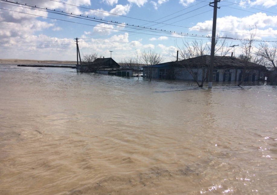
The investigation of climate and hydrological changes, encompassing the assessment of flood hazard, as well as flood prevention and forecasting capacities, took place in the Zhabay Riv-er Basin. Since 2000, Kazakhstan has been witnessing stable air temperature increase. In the target watershed, strong floods (2014) and destructive waves (2017) –
threatening the lives of the residents of the town of Atbasar located at the river mouth – were registered dur-ing the same period. The HEC-RAS hydraulic modeling software applied during the re-search demonstrated the extreme (crisis) risk for the most eastern and high risk for the south-ern town sections. The climate change forecast for 2030 and 2040 based on long-term means, compiled using regression equations, showed further air temperature growth by 0.8-2.2°C and precipitation growth by 7-22% in the Zhabay Basin. It means that in the future, warm period duration, snow melting intensity, and precipitation amount will likewise in-crease. The article presents the outcomes of analyzing the
short-term hydrological forecasts compiled using the Soil and Water Integrated Model (SWIM). The analysis results show 81-86% accuracy of flood forecasts based on independent validation years (2019 and 2020), in-dicating that the model can be used for operational purposes, i.e. generating short-term wa-ter flow and volume forecasts. The parameter optimization presented also allows applying the model for mid-, longand super long-term discharge forecasts for the Zhabay River. The study results may guide decision-makers in terms of long-term water resource
planning in the context of climate change, as well as water managers, utility operators, and emergency ser-vices in designing public prevention measures, constructing flood control and other engineering installations.
Download the Paper
Available in Russian
For citation: Kalashnikova, O., Nurbacina, A., Niyazov, J., (2023) Flood and flash flood risk assessment for sustainable development in the Zhabay river basin (Kazakhstan). Central Asian Journal of Sustainability and Climate Research. https://doi.org/10.29258/CAJSCR/2023-R1.v2-1/22-45.rus
Rerefences
Annual Bulletin on Monitoring the State and Climate Change of Kazakhstan: 2016 (2017). [Ezhegodnyi byulleten monitoringa sostoyaniya i izmeneniya klimata Kazakh-stana: 2016]. RSE “NITS RGP Kazhydromet” Research and Production Center, Astana. [in Russian];
Beketova, A. (2023). Poor investigation won’t save from floods [Nekachestvennoe rassledovanie ne spaset ot pavodkov]. 716.kz Online News Service (available at: https://716.kz/news/7056-vesna-blizko-nekachestvennoe-rassledovanie-ne-spaset-ot-pavodkov.html) [in Russian];
Brunner, G.W., Warner, J.C., Wolfe, B.C., Piper, S.S. and Marston, L. (2016). HEC-RAS, River Analysis System Applications Guide. US Army Corps of Engineers, Hydrologic Engineering Center: Davis, CA, USA;
Dyusekeyeva, D. (2022). Over 500 homes in the flood zone: Atbasar prepares for flood-ing [V zone podtopleniya bolee 500 domov: atbasar gotovitsya k pavodku] Aqmola News Online News Service (available at: https://aqmolanews.kz/en/2022/03/16/in-the-flood-zone-more-than-500-houses-atbasar-is-preparing-for-floods-video) [in Russian];
FAO of the United Nations (2023). (available at: http://www. fao.org/soils-portal/soil-survey/soil-maps-and-databases/faounesco-soil-map-of-the-world/en/);
Globeland30 (2023). (available at: http://www.globeland30.org/GLC30Download/index.aspx, https://landcover.usgs.gov/global_climatology.php);
GRASS4.1 Reference Manual (1993). US Army Corps of Engineers. Construction En-gineering Research Laboratories, Champaign, Illinois;
Guide for Hydrological Practice (2012). Vol. II, Ch. 7, Sec. 7.1. (7.1.1.) Subject Cover-age. WMO Publication, Geneva, 2012, p. II-7-1;
Forecasting Service Guided Tutorial [Nastavlenie po sluzhbe prognozov]. Sec. 3(1)., Gidrometeoizdat, Leningrad, 1962, p. 196 [in Russian];
HEC-RAS User`s Mannual (1998). HEC-RAS Documentation (available at: army.mil);
Hydrologic Engineering Center (CEIWR-HEC) (2022). (available at: https://www.hec. usace.army.mil/ software/hec-ras/download.aspx);
Kosenov, A. (2014). 330 homes flooded by melt water in Atbasar [Talye vody podtopili 330 domov v Atbasare]. Tengrinews.kz Online News Service (available at: https://tengrinews.kz/events/ talyie-vodyi-podtopili-330-domov-v-atbasare-253448/) [in Russian];.
Krysanova, V., Müller-Wohlfeil, D.I., Becker, A. (1996). Integrated Modelling of Hy-drology and Water Quality in mesoscale watersheds. Report No.18, July 1996, Potsdam Institute for Climate Impact Research (PIK), Germany, 32 p.;
Mihu-Pintilie, A., Cîmpianu, C.I., Stoleriu, C.C., Pérez, M.N., Paveluc, L.E. (2019). Us-ing high-density LiDAR data and 2D streamflow hydraulic modeling to improve urban flood hazard maps: A HEC-RAS multi-scenario approach. Water 2019, 11(9), 1832 (available at: https://doi.org/10.3390/ w11091832);
Ongdas, N., Akiyanova, F., Karakulov, Y., Muratbayeva, A., Zinabdin, N. (2020). Ap-plication of HEC-RAS (2D) for flood hazard maps generation for Yesil (Ishim) river in Kazakhstan. Water 2020, 12(10), 2672 (available at: https://doi.org/10.3390/w12102672);
Podrezov, O.A. (2019). Methods of statistical processing and analysis of hydrometeoro-logical observations: textbook for bachelor hydrometeorologists [Metody statisticheskoj obrabotki i analiza gidrometeorologicheskih nabljudenij: uchebnik dlja bakalavrov-gidrometeorologov]. Bishkek: KRSU, p. 170 [in Russian];
Sadvakasov, D. (2021). Snow as an annual climate threat [Sneg kak ezhegodnaya klimaticheskaya ugroza]. Vlast.kz. Online News Service (available at: https://vlast.kz/regiony/44981-sneg-kak-ezegodnaa-klimaticeskaa-ugroza.html) [in Russian].
This post is also available in: Русский (Russian)
Central Asia, Central Asia, climate change, climate change, HEC-RAS, HEC-RAS, hydraulic modeling, hydraulic modeling, hydrological modeling, hydrological modeling, Kazakhstan, Kazakhstan, short-term forecasting, short-term forecasting, SWIM, SWIM, water resources, water resources, Zhabay River, Zhabay River